Harlan County Lake (Nebraska) a Safe Haven for Whooping Cranes and other birds

Harlan County Lake (Nebraska)

by Chester McConnell, Friends of the Wild Whoopers

Friends of the Wild Whoopers (FOTWW) visited the U.S. Army Corps of Engineer’s (COE) Harlan County Lake recently to assess potential “stopover habitats” for Whooping Cranes. There is a growing need for more quality stopover areas during the Whoopers two 2,500 mile migrations each year. Typically, during migration, they stopover on lakes, natural wetlands and small ponds on private farms just to rest overnight. Like humans on a long trip they just need a small place to briefly stop, feed and then continue their journey.

While checking out potential areas to protect and develop for Whooping Cranes, FOTWW also looks for opportunities to help other wild critters. Importantly, Whooping Cranes are compatible with other wildlife and briefly share their habitats. Ensuring that sufficient areas with the proper conditions as stopover sites are available for Whoopers is important for the survival of the species. Practical management techniques implemented by conservation interest can help reduce potential morality that occurs during migration.

FOTWW and COE Tour Harlan County Lake

During FOTWW’s visit, Park Manager Tom Zikmund led us on a tour of the lake property so that we could to examine the most likely places that would provide Whooping Crane “stopover habitats”. Many potential areas were observed.

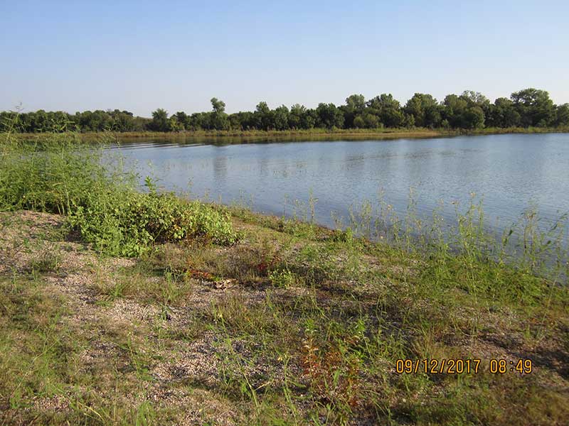
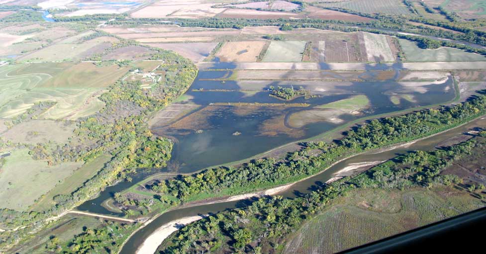
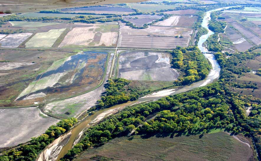
Harlan County Lake is large and has a comprehensive program. At top of conservation pool, the lake covers 13,250 surface acres. At top of the flood control pool, the lake covers 23,100 surface acres. A total of 17,750 acres of land surrounds the lake’s nearly 75 miles of shoreline.

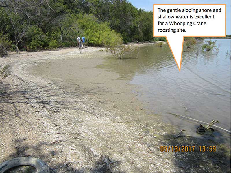
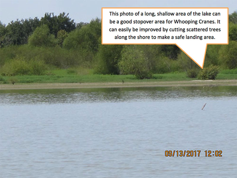
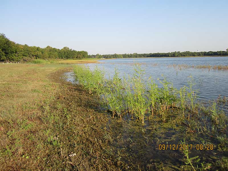
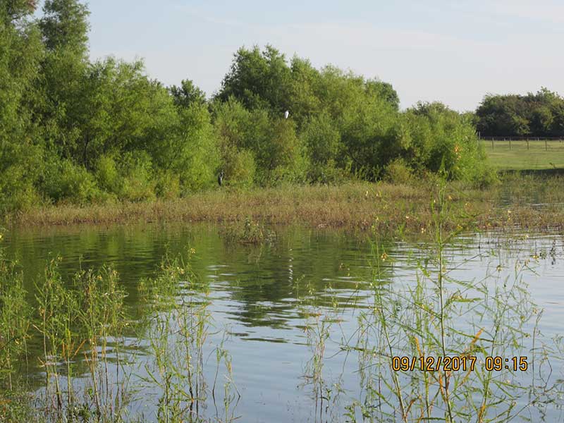
There have been considerable fluctuations in lake water levels over the years. During drawdowns of lake waters large expanses of mud flats and shallow pools are created that favor many wading birds including Whooping Cranes. Importantly much of the lake bed has a gradual rise in elevation. When water levels in the lake rise some shallow areas become too deep for wading birds while new shallow areas are created near the shore.

COE Stewardship Mission

The U.S. Army Corps of Engineers environmental stewardship mission is to manage and conserve natural resources, consistent with ecosystem management principles, while providing public outdoor recreation to serve the needs of present and future generations. The Corps works in cooperation with several partners including the Nebraska Game and Parks Commission. Because of this cooperative relationship, the Corps has been able to enhance and revitalize thousands of acres of land surrounding the lake.

Harlan County Lake’s 7,875 acres of grassland is primarily classified as mixed grass prairie. Native prairies are managed by prescribed fire and hay production. Such practices help prevent invasion by non-native species, enhance prairie community health and increase wildlife habitat values. These grasslands can also provide important foraging areas for Whooping Cranes.

An important and effective habitat enhancement tools is the COE’s Agricultural Lease Program on 3,500 acres. This program makes many acres of public lands available for lease to farmers for the purpose of crop and hay production. Leased lands agreements include specific conditions to protect and conserve soil and water while enhancing vegetation and wildlife resources. Major crops include corn, milo and wheat that are rotated annually. Leases require that portions of the crops be left in the fields to provide abundant food and cover for wildlife. These crop lands are near the lake and can also provide very important foraging areas for Whooping Cranes.

Recreation Uses of Harlan Lake

Although not a primary purpose for the construction of Harlan County Lake, recreation has increasingly become a major component in the Corp’s multiple use approach to managing our nation’s resources. Recreation and favorable fish and wildlife habitats are among those beneficial uses derived from this lake and others like it. With lake property open to all, there are many attractive areas for outdoor recreation including birding, water sports, hunting, fishing, and boating, or just relaxed living.

Harlan County Lake
Figure 1. Whooping Cranes stopping over for the night to rest and feed.

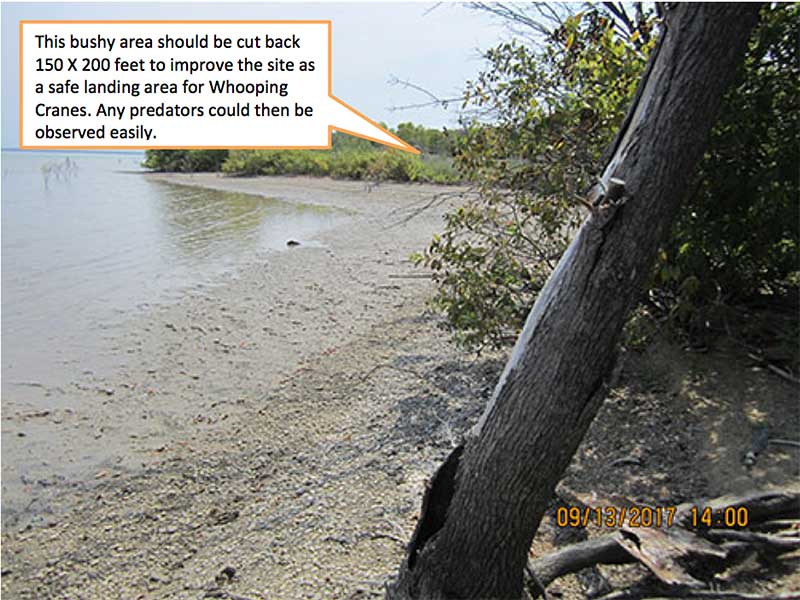
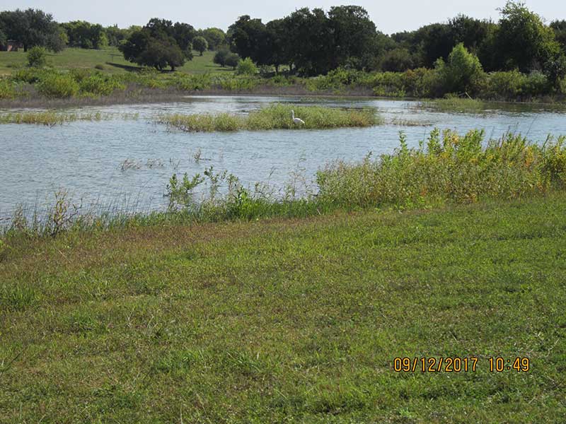
Some of Harlan County Lake’s shore area is developed for recreational use and Whooping Crane “stopover habitat” is not compatible with some of these areas. Importantly, considerable areas of the lake’s nearly 75 miles of shoreline is shallow and is available as good “stopover roosting areas” for the cranes. Whoopers normally roost in areas with a water depth of 2 inches to 10 inches to help protect themselves from predators.

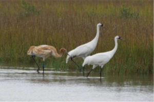
Several Whooping Cranes have been recorded using stopover sites on Harlan County Lake property. Whoopers normally migrate over or near Harlan County Lake during April (northward migration) and fall during October – November (southward migration). Whoopers normally stopover to rest late in the afternoon and depart early the following morning.

A big surprise to FOTWW is the use of Harlan County Lake by many species of birds.

COE Park Manager Tom Zikmund told FOTWW: “It has been an amazing year for migratory waterfowl here at Harlan County Reservoir.  Here are some of the highlights: An estimated one million snow geese stopped over on the lake from about February 26 – March 5. This is one of the largest numbers we have had over the years. In addition we had an estimated 50,000 Canada geese. Canada geese were here this winter from about December 20 thru February 1, 2018. Currently approximately 150 White Pelicans are on the lake. Also, there are currently about 15 different species of ducks on Harlan County Lake including mallards, greenwing teal, redheads, scaups, pintails, gadwalls, shovelers, merganzers, buffleheads, canvasbacks, and goldeneyes. We estimate that there are approximately 25,000 ducks on the reservoir. Likewise, some grebes and coots are showing up as well. We have observed several groups of sandhill cranes loafing on the exposed lake bed but to date no whooping cranes have been reported. Whooping cranes have stopped over on Harlan County Lake in the past but we have not spotted them recently. Some may have visited and were not observed.

Tom added, “The birding tourism is really picking up and we have had several groups and individuals stop by the lake office over the last few weeks to watch the migration.”

Harlan County Lake
Figure 2. The site is typical of the bluff area around north side of Harlan County Lake. The photos illustrate features of an excellent “stopover area” for Whooping Cranes to rest and roost. The flight glide paths to the shore area for approaching cranes is clear of obstructions from several directions. The shore is wide and long making it an excellent site for Whooping Cranes to land. Extensive horizontal visibility from the shore and water roost site allows Whooping Cranes to detect any predators that may be in the area. The slope of the shore and lake edge is gradual and water depths of 2 to 10 inches are readily available for roosting sites. There is little or no emergent or submerged vegetation in lake at this roost area. This area is 200 or more yards from human development or disturbance such as power lines. Over 11,000 acres of foraging areas are located in grasslands and nearby agriculture fields with various grain crops. There are wild foods in adjacent managed grasslands that provide an abundance of insects, wild seeds and other wild food. Numerous other birds use these same habitats.
Harlan County Lake
Figure 3. This site is typical of over a dozen sites along the 75 mile long lake shore. It is located north and west of the dam near Highway 193. It has similar preferred habitat features as those in Figure 2.
Share

Corps of Engineers’ Bardwell Lake is another stepping stone in the Whooping Crane migration corridor

Bardwell Lake – another stepping stone in the Whopping Crane migration corridor
by Pam Bates, Friends of the Wild Whoopers

Bardwell Lake is an important link in a virtual chain of lakes within the Whooping Crane migration corridor. Bardwell has been visited by wild Whooping Cranes several times in recent years. Friends of the Wild Whoopers (FOTWW) believe that such visits are increasing due to two factors. First, some of the traditional sites where Whooping Cranes have stopped over to rest and feed have been eliminated due to changes in land use. Many thousands of wetland acres and small ponds within the Whooping Crane migration corridor have been converted to other uses. Likewise the increasing population of Whooping Cranes is using additional areas to stopover to rest and feed. They must stop 15 to 20 times to rest and feed during each of their two 2,500 mile migrations each year. They migrate to and from their Texas coast wintering grounds to their Canadian nesting area.

FOTWW is evaluating U.S. Army Corps of Engineers (USACE) lakes within the Whooping Crane migration corridor to assist in protecting and improving existing habitats and to encourage development of new stopover habitats. Bardwell Lake is about 45 miles south of Dallas, TX and has much potential for habitat improvements.

USACE and FOTWW tour Bardwell Lake

FOTWW Wildlife Biologist Chester McConnell visited Bardwell Lake to assess potential “stopover habitats” for Whooping Cranes. Martin Underwood, USACE – Environmental Stewardship (CESWF) made arrangements for our visit. Martin Underwood, James Murphy (Deputy Operations Project Manager, Trinity Regional Project) and McConnell traveled to Bardwell Lake. After discussing the natural resource objectives for Bardwell Lake with Lake Manager Jeremy Spencer, we made a tour of the lake property to examine the most likely places that would provide Whooping Crane “stopover habitats”. FOTWW appreciates all involved with making preparations for an interesting, productive and enjoyable visit.

Bardwell Lake and Dam built for flood control and water conservation

Congress approved an act on March 31, 1960, authorizing construction of Bardwell Lake by the U.S. Army Corps of Engineers. Construction began in September 1963 with impoundment beginning in November 1965. The total construction cost was $12,630,000.

Built to provide flood control and water conservation, Bardwell Lake and Dam controls runoff from 178 square miles of drainage area. At conservation level the lake is 5.4 miles long, 1.2 miles at its widest point, and has a shoreline of 25 miles. The lake has a fee owned perimeter of 39 miles. The total fee simple acreage (government owned property) is 7,488 acres with 675 acres of flowage easement lands (private property the government has an agreement with the landowners to flood.) Of this total acreage in fee simple, 3,570 is water area and 3,918 acres is land area above the conservation pool elevation.

Although not a primary purpose for the construction of Bardwell Lake, recreation has increasingly become a major component in the U.S. Army Corps of Engineers’ multiple use approach to managing our nation’s resources. Recreation and favorable fish and wildlife habitats are other beneficial uses derived from this lake and others like it, built and operated by the Corps of Engineers.

Much of Bardwell Lake’s shore area is developed for recreational use and Whooping Crane “stopover habitat” is not compatible in some of these areas. The lake is shallow but most is not shallow enough for roosting areas. Whooping Cranes normally roost in areas with a depth of 2 inches to 10 inches. Importantly, some very good stopover habitats are located on the north western and north eastern areas of the lake shore. FOTWW recommended that Whooping Crane stopover habitat management efforts should focus on these areas.

Whooping Cranes observed on Bardwell Lake

According to Lake Manager Jeremy Spencer four Whooping Cranes have been observed on Bardwell Lake in recent years. Based on information from a recent U.S. Geological Survey study, 58 radio-tagged Whooping Cranes provided data on 2,158 stopover sites over 10 migrations and 5 years (2010-14). Several of these stopover sites were in the general vicinity of Bardwell Lake. Whoopers normally migrate over or near Bardwell Lake during March – (April (northward migration) and during October in the fall…

COE lakes within the 6 state migration corridor may become even more important to Whooping Cranes in the near future because of their locations and quality of “stopover habitats”. Bardwell Lake and others that are located in the mid-section of the Whooping Crane migration corridor can be especially valuable. As the crane population increases the migration corridor may also expand in width.

The photographs that follow were taken on Bardwell Lake. They show some very good stopover habitats that need a small amount of inexpensive management.

Bardwell Lake
Figure 1. This photo taken on the northeast side of lake illustrates a sample of a long expanse of open shore with a gentle slope into shallow water. The entire Bardwell Lake is shallow but the northeast side has over a mile of mostly open shore with a gradual slope into shallow water. The shore has some areas where trees are too close on the shore and need to be cut back so Whooping Cranes have an open glide path to a safe landing shore area.
Bardwell Lake
Figure 2. This photo depicts another section of shore on the northeast side of Bardwell Lake. Note that the shore is open with a gradual slope into very shallow water. This area of Bardwell Lake could be improved as a Whooping Crane stopover site if the bushes were cut back with a rotary cutter (Bush hog) a distance of 150 X 200 feet. The water is shallow all along this section of the shore. Much of the water is in the 2 inch to 10 inches depth range which the cranes need for roosting sites. Foraging for food is available in nearby agricultural fields.
Bardwell Lake
Figure 3. This photo was made on the northwest portion of Bardwell Lake. The water is shallow (one foot and less) in most of the area shown in this photo. Also much of the shore area is open with a few scattered trees. While this area could be a good stopover area currently, it can be improved by removing the few scattered trees on the shore. Much of the lake shore of the northwest arm of the lake is similar to this.
Share

Benbrook Lake, a surprise stopover habitat for Whooping Cranes in Texas

By Pam Bates, Friends of the Wild Whoopers

Friends of the Wild Whoopers (FOTWW) is continuing its efforts to encourage government agencies and Indian Reservations to manage portions of their lands to help wild Whooping Cranes. Whoopers and many other wildlife species often use the same wetland habitats and specific adjustments to portions of selected wetland sites could be beneficial to many species. FOTWW focuses its efforts on protecting existing Whooper habitats, planning needed habitat improvements where needed and encouraging landowner/managers to support our efforts. 

Benbrook Lake a nice surprise               

Chester McConnell FOTWW’s Wildlife Biologist is currently visiting U.S. Army Corps of Engineer (USACE) lakes in the 7 state Whooping Crane migration corridor to evaluate habitats. McConnell explained that “Friends of the Wild Whoopers is evaluating lakes, small ponds and wetlands throughout the mid-west to help protect and improve “stopover habitats” for the Whoopers.” He revealed that, “During a visit to the USACE Benbrook Lake in mid-Texas, I had a welcome surprise. I visited the lake to evaluate its suitability as a place where wild Whooping Cranes could stopover and rest during their two annual migrations through Texas. The lake had some excellent habitat in several locations.”

During our interview, McConnell divulged that, “I pondered what I might observe during my evaluation of a lake in the south west edge of the densely human populated city of Fort Worth. It certainly didn’t seem to be a place that Whooping Cranes would use to stopover to rest and feed. Yet, I have had many surprises during my long career and I have observed many unexpected behaviors by wild critters. During my review of records prior to my visit, I had learned that some Whooping Cranes had actually stopped over on the lake. And during my on-the-ground evaluation of Benbrook Lake I was indeed surprised to observe that there were ample, good quality habitat sites with all the features that the cranes need to make a visit.”

Benbrook Lake
One juvenile and two adult Whooping Cranes. Photo by John Noll

McConnell’s evaluation revealed that, “Some of the habitat around Benbrook Lake is currently in excellent condition to serve as secure Whooping Crane “stopover habitats”. However some of the potential habitats will not be useful because they are too close to developed areas and trees grow too close to the lake shore. Still, several such areas have potential and can easily and inexpensively be developed into stopover habitat. Importantly open landscapes near most favorable stopover habitats allow Whooping Cranes to easily locate the sites and provide ready observation of any predator threats (see photos below). The scarcity of tall bushes and trees close to these habitats provide easily accessible flight approach corridors for Whooping Cranes entering the area.

Based on information from a recent U.S. Geological Survey study, 58 radio-tagged Whooping Cranes provided data on 2,158 stopover sites over 10 migrations and 5 years (2010-14). Several of these additional stopover sites were also in the general vicinity of Benbrook Lake. And one Whooper has been recorded on the lake.

Whoopers normally migrate over or near Benbrook Lake during (March – April (northward migration) and fall during October – November (southward migration). They normally stopover to rest late in the afternoon and depart the following morning.

Benbrook Lake important to Whooping Cranes

USACE lakes within the 7 state migration corridor may become even more important to Whooping Cranes in the near future because of their locations and quality of “stopover habitats”. Benbrook Lake and others that are located in the mid-section of the Whooping Crane migration corridor are very important. As the crane population increases they will need more areas to stop over and rest and forage for food. Any Whooping Cranes that may stopover during their fall migration still have over 400 miles remaining to fly to their winter home on Aransas National Wildlife Refuge on the Texas Gulf coast. And if they stopover while migrating north to their nesting area on Wood Buffalo National Park, Canada, they have over 2,000 miles more to fly.

Benbrook Lake
Figure 1. This photo on shoreline of north Holiday Park Day Use area is an excellent example of a “stopover habitat” for Whooping Cranes. It provides a flight guide path for approaching Whoopers to easily land on shore. The shore area is free of tall thick vegetation which allows the cranes to readily observe predators. The shore’s gradual slope allows the birds to wade into the shallow water (2” inches to 10” depths) to roost. Foraging for food is available in the shallow water along the shoreline and in the grass area on shore.

FOTWW was pleased to have the opportunity to visit USACE’s Benbrook Lake. The lake and surrounding land area has good fish and wildlife habitat and some excellent Whooping Crane “stopover habitats”. We were pleased to learn that Whooping Cranes have already begun using the lake properties along with thousands of waterfowl, American egrets and other critters that need wetlands. FOTWW believes that Whooping Crane use of Benbrook Lake will continue and increase as their population continues to increase.

Benbrook Lake also allows a number of other uses of the land and waters including fishing, hunting, birding, camping and other types of recreational activities. Outdoor recreational activities are open to the general public.

Benbrook Lake
Photo by Klaus Nigge

Martin Underwood, USACE – Environmental Stewardship (CESWF) made arrangements for our visit. After discussing the natural resource objectives for Benbrook Lake, Mr. Underwood guided us on a tour of the lake property to examine the most likely places that would provide Whooping Crane “stopover habitats”. FOTWW appreciates Mr. Underwood for making preparations for an interesting, productive and enjoyable visit.

Benbrook Lake
Figure 2. This shallow grass area could be a good place for Whooping Cranes to stopover and forage for insects and aquatic animals. Likewise, it is a good place for them to rest and roost. It provides flight guide paths from any direction for approaching Whoopers to easily land in the grass or on shore.. The shore area is free of tall thick vegetation which allows the cranes to readily observe predators. The shore’s gradual slope allows the birds to wade into the shallow water (2” inches to 10” depths) to roost.
Benbrook Lake
Figure 3. This photo shows an area that Whooping Cranes will not use as a roost site. The trees and bushes on the shore are too thick and tall. This site could be developed into a suitable “stopover area if, lake managers would cut back the trees near the shore back to a distance of about 100 feet. Fortunately however, Benbrook Lake currently has ample roosting areas for Whooping Cranes. Yet, as the Whooper population increases and additional habitats are needed, such sites are available for development.
Benbrook Lake
Figure 4. Holiday Park Campground area. This photo includes an open flight glide path and landing area. Once on the ground Whooping Cranes can detect any predators in the area. Then they can walk down gentle slopes into the shallow water area (2” to 10” depth). Foraging for food is available in the shallow water, grass areas and on shore. This is an excellent example of a “stopover habitat” for Whooping Cranes to use as a roost site. Farther along the shore there are other potential roost sites.


Share

Corps of Engineers Milford Lake, Kansas Stands Out as Whooping Crane Stopover Habitat

Milford Lake was one of the many U.S. Army Corps of Engineer lakes that Friends of the Wild Whoopers (FOTWW) has visited and evaluated for possible whooping crane “stopover” habitat. As the largest man-made lake in Kansas, FOTWW is very pleased at what Milford Lake has to offer the wild flock of whooping cranes as they migrate along the Central Flyway. Read our report below to learn what we found about Milford Lake and its habitat. ~ Pam Bates, FOTWW

Milford Lake, a stand out as Whooping Crane Stopover Habitat

by Chester McConnell, Friends of the Wild Whoopers

Friends of the Wild Whoopers (FOTWW) is continuing its efforts to encourage government agencies and Indian Reservations to manage portions of their lands to help wild Whooping Cranes. Whoopers and many other wildlife species often use the same wetland habitats and specific adjustments to portions of selected wetland sites could be beneficial to many species. FOTWW focuses its efforts on planning needed management adjustments and encouraging their completion.

FOTWW evaluates Milford Lake, KS

FOTWW was pleased to have the opportunity to recently visit the U.S. Army Corps of Engineer (USACE) Milford Lake in eastern Kansas. The lake and surrounding land area has good fish and wildlife habitat and some excellent Whooping Crane “stopover habitats”. We were pleased to learn that Whooping Cranes have already begun using the lake properties along with tens of thousands of waterfowl and other critters that need wetlands and nearby agricultural fields to forage, rest and roost. Both USACE and Kansas Department of Wildlife, Parks and Tourism (KDWP&T) have joint management responsibilities on the lake and maintain ongoing agricultural programs to provide excellent, nearby foraging areas for Whooping Cranes and other wildlife.

FOTWW believes that Whooping Crane use of Milford Lake will continue and increase as their population continues to increase.

Multiple parties manage multiple wetland complexes

The USACE and KDWP&T have, with assistance from other parties, created and manage 10 wetland complexes with individual wetlands varying from 20 to 250 acres and totaling about 2,300 acres. These wetlands are regulated by water control structures, which allow for precise manipulation of the water surface and acreage. FOTWW was most gratified to observe the remarkable development and operation of these wetlands. Figures 1 and 2 are photos and maps of two of the ten wetland areas.

There are three stationary pumps and six floating pump structures to pump water from the Republican River to fill the wetlands. These wetland complexes provide manageable wetland habitat benefiting breeding and migrating waterfowl, shorebirds, wading birds and other wildlife species. They also increase habitat diversity in the upper portion of Milford Reservoir by providing habitat in the form on aquatic vegetation, shallow water, food, nesting, and resting sites

The 10 wetland cells consist of earthen embankments, rock covered spillways and stoplog water control structures. KDWP&T personnel use pumps when necessary to maintain water depths of 1 to24 inches. The relatively new wetlands provide a consistent, quality habitat for migrating species and increased local populations of wildlife.

FOTWW appreciates the interest and cooperation of the USACE and KDWP&T officials. We are grateful to David Hoover and Ken Wenger of USACE. who led us on a tour of Milford Lake project and provided us with documents and photographs that assisted in our evaluation. And we are very appreciative of the tremendous work by Kristin Kloft, KDWP&T who manages and protects the wetland areas.

Milford Lake
Figure 1. Westar/Martin Wetlands Area contains approximately 135 acres and was constructed by Westar Energy. A permanent pump is located on this area and floods the seasonally cropped area. Historically this area has been farmed. The lower 46 acres has been removed from production and will not be managed as a moist soil unit.  The upper area will continue to be cropped.  A rotation of corn, milo and soybeans are the crops used by farmers

Milford Lake


Milford Lake
Figure 2. West Broughton Wetland contains approximately 140 acres. It was constructed by the Kansas National Guard. This cell is a “Youth Only” area for persons ages 17 and under. Special regulations apply for use. There is a permanent pump at the cell to flood the area for waterfowl and other wildlife that use aquatic habitats, A portion of the area is seasonally farmed. Normally, 1/8th-1/6th.  of the crop is left on the area as food for wildlife.


Share