ELM CREEK — A design and cost estimate might be ready in September for the first new Platte River Recovery Implementation Program water project to proceed since the large J-2 water-retiming reservoirs project proposed for southwest of Overton were determined to be too expensive.
The main feature of the new project will be about 6.5 miles of small berms spread over roughly 300 grassland acres in the southeast corner of the 3,000-acre Cottonwood Ranch. It is owned by Nebraska Public Power District and managed by the PRRIP on the south side of the river between Elm Creek and Overton.
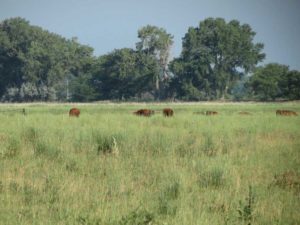
Platte River Recovery Implementation Program Director of Habitat Management and Rehabilitation Jason Farnsworth, left, and Executive Director Jerry Kenny describe for 2017 Nebraska Water and Natural Resources Tour participants a water project at a Cottonwood Ranch grassland southwest of Elm Creek. The plan is to build small berms to hold water on the 300-acre site at times when high flows allow diversions from the Platte River, at the tree line in the background. Lori Potter, Kearney Hub
PRRIP Director of Habitat Management and Rehabilitation Jason Farnsworth said the benefits will be better roosting and foraging habitat for migrating whooping cranes and the ability to retime water in the river.
The Platte Program is a combined effort of the U.S. Department of Interior, Nebraska, Wyoming and Colorado to protect critical habitat in and around the Central Platte River for threatened and endangered species: whooping cranes, interior least terns and piping plovers.
The three main components for the first 13-year increment are to protect 10,000 acres of land habitat — PRRIP Executive Director Jerry Kenny of Kearney said 12,000 acres have been acquired — and reduce depletions to river target flows by 130,000-150,000 acre-feet on average.
He said program partners brought 80,000 a-f of water toward the goal, leaving 50,000-80,000 a-f still to achieve.
Grazing leases and public access for hiking and waterfowl hunting will likely continue at the Cottonwood Ranch site where a berm-focused Platte River Recovery Implementation Program water project may be built late this year or early in 2018. Lori Potter, Kearney Hub
The Cottonwood Ranch property was acquired as wet meadow and lowland grassland habitat, Farnsworth said, “but we had issues keeping water in this area.”
“Soon, we will incorporate this whole area as a broad-scale recharge project that can hold water from the Platte if there is a flow excess,” he said, beyond targets set by the U.S. Fish and Wildlife Service.
Berms will be 5-6 feet tall.
“It will be a couple hundred acres of water 6 to 12 to 14 inches deep. That’s perfect for these birds,” Farnsworth said about the habitat that will be created to attract migrating whooping cranes.
To read more of this article by Lori Potter of the Kearney Hub, click here.
***** FOTWW’s mission is to help preserve and protect the Aransas/Wood Buffalo
population of wild whooping cranes and their habitat. *****
Friends of the Wild Whoopers is a nonprofit 501(c)3 organization.
The Prairie Pothole Region of the United States and Canada is where over half of North America’s waterfowl nest. This area is referred to as the “Duck Factory”. Credit: Krista Lundgren/USFWS
Most of us, if given a choice, would steer clear of potholes. Many migratory birds, however, actively seek out potholes — provided you’re talking about the thousands of temporary, seasonal, and semi- permanent wetlands wetlands known as “potholes” that are found in the prairies of the Northern Great Plains. Despite their importance to wildlife, these shallow wetland “potholes” are often drained, filled, or degraded by development and agricultural practices. With its mission focus on wetlands restoration and conservation, the Service naturally has placed a priority on enhancing, restoring and acquiring bird habitat in what’s known as the Prairie Pothole Region. What might come as a surprise, however, is that projects in the region are being funded with legal settlement money from the 2010 oil spill that took place in the Gulf of Mexico.
On January 29, 2013, BP pled guilty to 14 criminal counts stemming from its actions related to the Deepwater Horizon oil spill, including one misdemeanor count of violating the Migratory Bird Treaty Act. As part of the settlement, BP agreed to pay $100 million to the North American Wetlands Conservation Fund (NAWCF) to support projects focused on wetlands restoration and conservation in the United States, Canada and Mexico. According to the agreement, those organizations that apply to NAWCF for some of the $100 million need to show that their projects are “designed to benefit migratory bird species and other wildlife affected by the … oil spill.” The organizations must also match the grants at least dollar to dollar, so in effect, more than $200 million will be spent in this way on species and their habitats affected by the spill.
“A lot of other organizations are putting a lot of money in the Gulf region,” says Mike Kreger, Special Assistant to the Assistant Director for Migratory Birds, “because that’s where the oil spill occurred.” He says the Service, however, is focused on the fact that eligible projects can benefit an affected species at any stage of its migratory cycle in North America. That means settlement money can fund projects in the Prairie Pothole Region, which is concentrated in the Dakotas and is arguably the most productive nesting area for migratory waterfowl in North America.
“The Prairie Pothole Region is what we call ‘America’s Duck Factory,’” Kreger says. “As so many of our birds depend on this Prairie Pothole Region, it’s a good place to put [BP settlement] dollars.”
Of the $100 million in BP settlement money placed in NAWCF, $70 million was earmarked for the United States. As of February 2015, $20 million in grants has been awarded to support 17 U.S. projects. Seven of these are Prairie Pothole Region-related and will receive grants that total $8.5 million.
The Migratory Bird Conservation Commission (MBCC) makes the final decision on how to spend these NAWCF funds. In the most recent round of proposals approved for funding (November 2014), commission members awarded $2 million to a project aimed at protecting 10,074 acres of the Prairie Pothole Region located in North Dakota through conservation easements; the land will be added to the Service’s National Wildlife Refuge System. Another grant, for $1 million, went to a proposal co- submitted by the Service for a project that focuses on the Prairie Pothole Region west of the James River in South Dakota. This grant will permanently protect 3,651 acres of wetlands and adjacent grasslands to be managed as Game Production Areas. Funds will also be used to restore and enhance 4,759 acres of “pothole” wetlands currently at risk of conversion to cropland.
The Service sometimes applies for NAWCF funding for projects, but is more often involved on the other side of the grant process. For example, Director Dan Ashe represents the Service on the North American Wetlands Conservation Council, which reviews proposals and recommends projects for funding to the MBCC. In addition, the Service’s Migratory Bird Program administers those projects the MBCC has selected to receive NAWCF grant money. This work includes processing grant paperwork and regularly monitoring grant projects to ensure they are complying with all regulations.
“The Service is committed to achieving large-scale, sustainable restoration of the Gulf of Mexico,” says Linda Walker, Senior Advisor for Gulf Restoration for the Service. “To do this, you actually need to take a step back, look north and consider the vast area that drains into the Gulf. Awarding BP settlement money for projects in areas like the Prairie Pothole Region can help ensure there are critical food, nesting and resting areas for birds heading for the Gulf not only now, but down the road.”
friendsofthewildwhoopers.org
***** FOTWW’s mission is to help preserve and protect the Aransas/Wood Buffalo
population of wild whooping cranes and their habitat. ***** Friends of the Wild Whoopers is a nonprofit 501(c)3 organization.
Crane Trust has shared an inspirational, beautiful video with Friends of the Wild Whoopers and now we want to share it with you. The video includes some beautiful photography of the lands managed by Crane Trust and some of the critters that use that land. The video is part of a larger ongoing behavioral study…a good blend of beauty and science that hopefully gives people a sense of connection to this great part of the world in Nebraska. Enjoy this Crane Trust video and pass it along.
***** FOTWW’s mission is to help preserve and protect the Aransas/Wood Buffalo
population of wild whooping cranes and their habitat. *****
In March, Friends of the Wild Whoopers reported on the need to learn more about resting/feeding sites along the whooping crane migratory route. (See Whooping Crane Tracking Study) In order to learn more about the Aransas-Wood Buffalo whooping crane population needs during migration, the Whooping Crane Tracking Partnership began banding and tracking them in 2009. Banding of the whooping cranes has been completed and preliminary findings are currently being compiled. Many key areas have already been identified where the whooping cranes stop over during their 2,500 mile migration. Other useful insights “into this here-to-fore little-know world of whooping crane stopover habitat” are being studied.”
In their latest Newsletter, the Crane Trust offers us some more insight and details about the Whooping Crane Tracking Partnership’s study.
Article from Crane Trust Spring 2014 Newsletter
Suitable habitat for whooping cranes to stop, rest and feed during their spring/fall migration is critical for the Aransas-Wood Buffalo population to complete its 2,500-mile journey each way. These stopover sites are the focus of a comprehensive ground-based study to improve our understanding of the specific habitats and locations selected by whooping cranes during their migration—and are vital for the species recovery. Above Photo: Whooping cranes require suitable stopover sites to complete their spring/fall migration. Without them, the 5,000-mile journey would not be possible. Photo by John Conklin, Canadian Wildlife Service.
Initiated in 2012 by the Platte River Recovery Implementation Program and researchers from the Crane Trust and the US Geological Survey, the ground-based study was in full swing for the 2014 spring migration. To date, more than 250 stopover sites have been visited and characterized by researchers between northern Texas and North Dakota. The result to date is the most exhaustive aggregation of data ever collected on whooping crane stopover sites and their utilization by migrating cranes. Above Photo: Maximum depth was one of over a dozen water-related measurements taken at sites where water was present. Distance to water, bank slope, land cover of nearest shoreline, and wetland classification were among the others.
Individual stopover sites were located using GPS tracking data from the Whooping Crane Tracking Partnership’s telemetry study and were visited by one of three regional research teams. Each team spent roughly one day in the field for every two days in the office contacting landowners and collecting/inputting time-sensitive measurements. Key measurements and their application included 360° on-location photography, GIS mapping of habitat types and land covers, food types and availability, land cover and management practices, endangering and visually obstructive features, water characteristics (if present), and other variables. Above Photo: The Crane Trust’s Ryan Joe creates GIS map of stopover site using field data collected this spring. The finished product will depict key features and habitats, providing a valuable reference for visual analysis.
The precise arrival and departure times of the whooping crane(s) and their movements within each stopover site area were also recorded. Sites were visited after whooping cranes had departed, so as to not disturb migrating birds and to record observations and measurements as close to the bird’s departure as possible. Above Photo: Habitat variations and similarities were observed throughout the migration corridor. The above photo was indicative of a stopover site in the Nebraska-central region.
While complete study results aren’t expected until 2015, preliminary findings are already providing useful insights into this here-to-fore little-known world of whooping crane stopover habitat. When complete, the Platte River Recovery Implementation Program, the Crane Trust and other conservation organizations/agencies will be able to use this comprehensive data to better inform (and improve) habitat management practices and conservation strategies to aid the species recovery.
***** FOTWW’s mission is to protect the Aransas/Wood Buffalo population
of wild whooping cranes and their habitat. *****