Bardwell Lake - another stepping stone in the Whopping Crane migration corridor
by Pam Bates, Friends of the Wild Whoopers
Bardwell Lake is an important link in a virtual chain of lakes within the Whooping Crane migration corridor. Bardwell has been visited by wild Whooping Cranes several times in recent years. Friends of the Wild Whoopers (FOTWW) believe that such visits are increasing due to two factors. First, some of the traditional sites where Whooping Cranes have stopped over to rest and feed have been eliminated due to changes in land use. Many thousands of wetland acres and small ponds within the Whooping Crane migration corridor have been converted to other uses. Likewise the increasing population of Whooping Cranes is using additional areas to stopover to rest and feed. They must stop 15 to 20 times to rest and feed during each of their two 2,500 mile migrations each year. They migrate to and from their Texas coast wintering grounds to their Canadian nesting area.
FOTWW is evaluating U.S. Army Corps of Engineers (USACE) lakes within the Whooping Crane migration corridor to assist in protecting and improving existing habitats and to encourage development of new stopover habitats. Bardwell Lake is about 45 miles south of Dallas, TX and has much potential for habitat improvements.
USACE and FOTWW tour Bardwell Lake
FOTWW Wildlife Biologist Chester McConnell visited Bardwell Lake to assess potential “stopover habitats” for Whooping Cranes. Martin Underwood, USACE - Environmental Stewardship (CESWF) made arrangements for our visit. Martin Underwood, James Murphy (Deputy Operations Project Manager, Trinity Regional Project) and McConnell traveled to Bardwell Lake. After discussing the natural resource objectives for Bardwell Lake with Lake Manager Jeremy Spencer, we made a tour of the lake property to examine the most likely places that would provide Whooping Crane “stopover habitats”. FOTWW appreciates all involved with making preparations for an interesting, productive and enjoyable visit.
Bardwell Lake and Dam built for flood control and water conservation
Congress approved an act on March 31, 1960, authorizing construction of Bardwell Lake by the U.S. Army Corps of Engineers. Construction began in September 1963 with impoundment beginning in November 1965. The total construction cost was $12,630,000.
Built to provide flood control and water conservation, Bardwell Lake and Dam controls runoff from 178 square miles of drainage area. At conservation level the lake is 5.4 miles long, 1.2 miles at its widest point, and has a shoreline of 25 miles. The lake has a fee owned perimeter of 39 miles. The total fee simple acreage (government owned property) is 7,488 acres with 675 acres of flowage easement lands (private property the government has an agreement with the landowners to flood.) Of this total acreage in fee simple, 3,570 is water area and 3,918 acres is land area above the conservation pool elevation.
Although not a primary purpose for the construction of Bardwell Lake, recreation has increasingly become a major component in the U.S. Army Corps of Engineers’ multiple use approach to managing our nation’s resources. Recreation and favorable fish and wildlife habitats are other beneficial uses derived from this lake and others like it, built and operated by the Corps of Engineers.
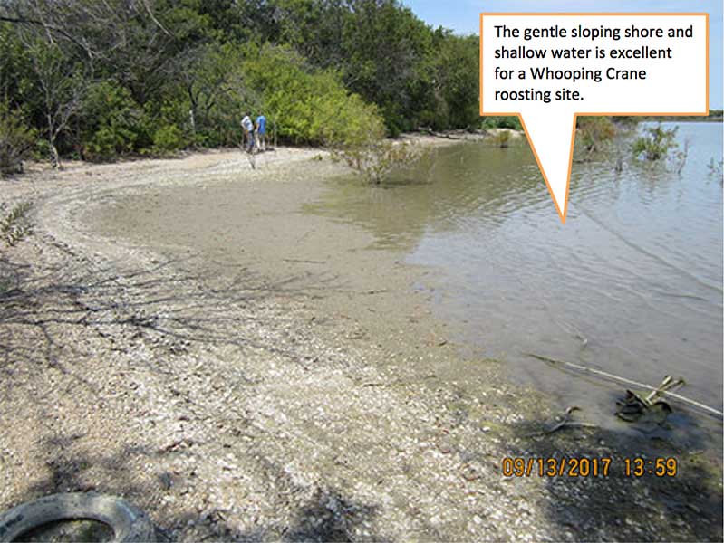
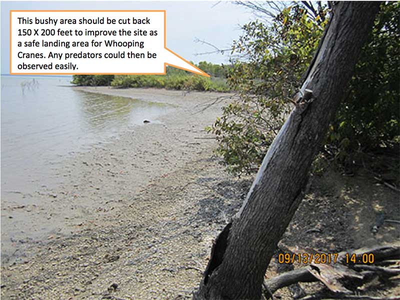
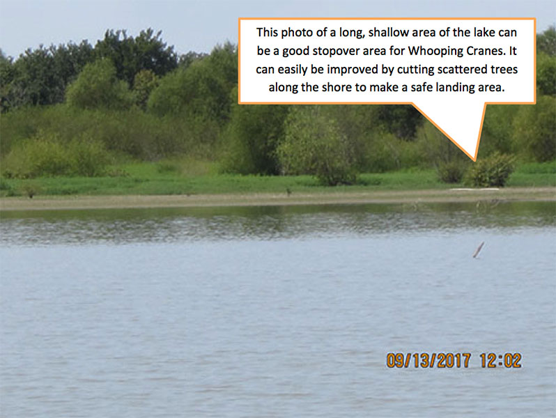
Much of Bardwell Lake’s shore area is developed for recreational use and Whooping Crane “stopover habitat” is not compatible in some of these areas. The lake is shallow but most is not shallow enough for roosting areas. Whooping Cranes normally roost in areas with a depth of 2 inches to 10 inches. Importantly, some very good stopover habitats are located on the north western and north eastern areas of the lake shore. FOTWW recommended that Whooping Crane stopover habitat management efforts should focus on these areas.
Whooping Cranes observed on Bardwell Lake
According to Lake Manager Jeremy Spencer four Whooping Cranes have been observed on Bardwell Lake in recent years. Based on information from a recent U.S. Geological Survey study, 58 radio-tagged Whooping Cranes provided data on 2,158 stopover sites over 10 migrations and 5 years (2010-14). Several of these stopover sites were in the general vicinity of Bardwell Lake. Whoopers normally migrate over or near Bardwell Lake during March - (April (northward migration) and during October in the fall…
COE lakes within the 6 state migration corridor may become even more important to Whooping Cranes in the near future because of their locations and quality of “stopover habitats”. Bardwell Lake and others that are located in the mid-section of the Whooping Crane migration corridor can be especially valuable. As the crane population increases the migration corridor may also expand in width.
The photographs that follow were taken on Bardwell Lake. They show some very good stopover habitats that need a small amount of inexpensive management.