The Whooping Crane (Grus americana) is one of North America’s most endangered species. There is only one wild, self-sustaining migratory population of Whooping Cranes, the Aransas–Wood Buffalo population (AWBP). The birds of the AWBP migrate 4,000 km twice each year between their nesting grounds in northern Canada and their wintering grounds on the Texas Gulf Coast. During migration, AWBP Whooping Cranes must land at suitable ponds or wetlands to forage, rest or roost. The Whooping Crane Recovery Plan, developed by federal wildlife agencies in Canada and the USA, calls for the protection and management of Whooping Crane stopover locations within the migration corridor. Although major stopover areas have been protected, many other smaller sites remain to be identified. However, the Recovery Plan offers no specific entity to identify, protect and manage the latter. To address these deficiencies in information and activity, Friends of the Wild Whoopers partnered with the United States Army Corps of Engineers (USACE) within the AWBP migration corridor to share information about Whooping Cranes and their habitat needs and identify potential stopover locations on USACE properties that could be protected and managed for cranes. This partnership identified 624 potential stopover sites on 34 USACE lakes, principally in North and South Dakota, Nebraska, Kansas, Oklahoma and Texas, with commitments to manage the habitats as resources allow.
To read the entire paper, click here for full text version of it.
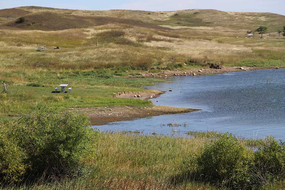
One of many stopover habitats evaluated
Excellent “stopover roost site” for Whooping Cranes. Number “1” points out the glide path for Whooping Cranes landing on lakeshore. The site is clear of obstructions and provides a gradual slope into the shallow water. Horizontal visibility around the roost site is good. Number “2” points out the shallow water from 2 to 10 inches deep in roost area. Whoopers can feed on aquatic animal in the lake and forage on insects and grains in nearby fields.
***** FOTWW’s mission is to help preserve and protect the Aransas/Wood Buffalo population of wild whooping cranes and their habitat. *****
Friends of the Wild Whoopers is a nonprofit 501(c)3 organization.
Friends of the Wild Whoopers (FOTWW) is continuing to work on its joint Whooping Crane “stopover habitat” with the U.S. Army Corps of Engineers (USACE). The project involves the 7 state migration corridor within in the states of Texas, Oklahoma, Kansas, Nebraska, South Dakota, North Dakota and Montana. FOTWW has completed its evaluation of Lake Sharpe properties in South Dakota and our Wildlife Biologist Chester McConnell provided a summary of their findings and recommendations.
McConnell emphasized that FOTWW appreciated USACE personnel who accompanied us on our field evaluation. “They were well informed about the lake’s abundant habitats and management needs. So, together, we successfully identified many stopover habitats that needed only minor management” explained McConnell.”
Habitat threats continue
Today Whooping Cranes are facing continuing threats to their habitats. During their two 2,500 miles migration from their Canadian nesting habitats and their winter habitats on the Texas coast they must stop 15 to 30 times to rest and feed. Secure stopover habitats are needed throughout the migration corridor approximately every 25 miles. And more secure wintering habitats are needed along the Texas coast near the Aransas National Wildlife Refuge. Currently about half of the population winters off the Aransas National Wildlife Refuge where they are not as safe. Continuous development along the coast is taking a serious toll on habitat.
FOTWW believes that the wild Whooping Cranes in the Aransas/Wood Buffalo population are capable of taking care of themselves with two exceptions. They need (1) humans to protect their habitats and (2) humans to stop shooting them. We firmly believe that the USACE can do much to protect and manage many “stopover habitats” within the migration corridor wetland habitats while other areas could be enhanced with minor, low cost work.
Working partnership
The USACE and FOTWW operate under a Memorandum of Understanding that allows FOTWW to focus on Whooping Crane habitat assessment and management recommendations on lands under USACE jurisdiction. We first need to determine if any suitable areas could be managed, or appropriately developed, to provide stopover habitats for Whooping Cranes. The next step would be to work to encourage appropriate management.
McConnell explained that “we have learned that USACE lakes within the 7 state migration corridor are very valuable to migrating Whooping Cranes. And we believe they are likely to become even more important to Whooping Cranes in the near future because of their locations and quality of “stopover habitats”. Lake Sharpe and others that are located in the Whooping Crane migration corridor can be especially valuable. As the crane population increases the migration corridor may also expand in width.
Lake Sharpe
Lake Sharpe is just one of the 35 USACE lakes that FOTWW has evaluated. We are aware that Whooping Cranes have visited Lake Sharpe and we expect that to continue and increase. United States Geological Survey personnel used location data acquired from 58 unique individuals fitted with platform transmitting terminals that collected global position system locations. Radio-tagged birds provided 2,158 stopover sites over 10 migrations and 5 years (2010–14) using individual Whooping Cranes. Whooping Cranes were also observed in the vicinity of Lake Sharpe property several times.
Figure 1. Deer and other wildlife species often use the same habitats as Whooping Cranes.
McConnell explained that during migration Whooping Cranes often stop over on private lands, wildlife areas, lakes and some military bases. However, many private lands are being more intensively managed and face various forms of development. And some wetlands are becoming dryer due to global warming. FOTWW contends that lands and waters on USACE, military bases and Indian Reservations within the migration corridor can provide much needed relief. Some of these lands can be developed and/or managed to provide more stopover habitats for endangered Whooping Cranes. Importantly, habitats for the cranes also benefit many other species of wildlife and fish. So Whooping Cranes are compatible with other wildlife species using the same habitats.
Costs
The most expensive part of establishing or improving habitat is land cost. If projects can be accomplished on government lands and Indian Reservations, the cost would be relatively minimal. Importantly any habitat projects deemed to be incompatible with the mission of the agencies involved would not be considered by FOTWW.
FOTWW has completed habitat evaluations on 32 military facilities, 8 Indian Reservations and 35 USACE lakes within the wild Whooping Crane migration corridor. Most of these properties currently have some suitable stopover habitats but there is much more potential explained McConnell.
A look at Lake Sharpe
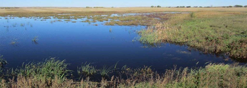
The following photos are a sample of the various examples of the Whooping Crane “stopover habitats” that we observed on Lake Sharpe.
Figure 2. Counselor Creek: This photo also on Counselor Creek was made after heavy rains and water levels were higher than normal. At normal levels the stream banks are much wider as indicated by the yellow arrow and would be useful “stopover habitats”. The vegetation on stream sides could be treated with herbicide to create wider open strips approximately 30 feet by 100 feet long. This would allow habitat openings wide enough the be useful to Whoopers during all but extreme high water levels.Figure 3. Good Soldier Creek. Focus on the water along the edge of the land area. The light color area is shallow water. Such areas are good foraging sites for the Whoopers. These areas are also prime roosting areas for Whooping Cranes. They like shallow water about 2 inches to 10 inches in depth to roost in. The 5 feet tall Whooping Cranes can defend themselves against predators in shallow water.Figure 4. Medicine Creek. This photo includes some excellent “stopover habitat” for migrating Whooping Cranes. The area is a safe landing site. Note the openness which allows the cranes to see in every direction and detect predators In addition this surrounding area has an abundance of plant seeds and insects for a food source. The cranes like such areas to spend several days to rest and feed.Figure 5. Medicine Creek. The area along the shore and 300 feet back is an excellent location for Whooping Cranes to land. Caution is needed however because of the fence (red marker) which could cause injure or kill Whooping Cranes that may crash into it during low flight. A management project should remove the fence or relocate it an additional 300 feet back from the water edge. Otherwise this location is excellent as a “stopover site” for the cranes.
***** FOTWW’s mission is to help preserve and protect the Aransas/Wood Buffalo
population of wild whooping cranes and their habitat. *****
Friends of the Wild Whoopers is a nonprofit 501(c)3 organization.
Friends of the Wild Whoopers and Corps of Engineers visit to Lewis and Clark Lake to evaluate potential Whooping Crane “stopover habitats”
By Chester McConnell, FOTWW
After receiving dozens of messages from concerned members, Friends of the Wild Whoopers decided to let you know all is OK. The virus has not infected any of our staff. Importantly, however, the virus has caused us to discontinue travel while there is a possibility of us being infected. When we are in the field, we travel an average of 1,500 miles each trip. During this travel we eat in many different restaurants, sleep in different motels each night and meet with about two dozen people. This type of living causes one to take a chance of becoming infected. So we have made the decision to halt our Whooping Crane “stopover habitat” project until conditions have improved. One good factor in this is that we are catching up on administrative responsibilities.
So, I also plan to let you know some details about our most recent joint Friends of the Wild Whoopers (FOTWW) – Corps of Engineers (COE) “stopover habitat” project that some members have requested. I will begin with some details about our last field trip to Nebraska, South Dakota, North Dakota and Montana. During this trip we visited seven COE lakes, met with the staffs of each lake and made long field trips to evaluate potential Whooping Crane “stopover habitats”. We examined some excellent habitats and many sites that could be improved and/or protected with a minimal amount of time and sound management.
The seven lakes we visited on this trip are Lewis and Clark Lake (NE/SD), Lake Francis Case (SD), Lake Sharpe (SD). Oahe Lake (SD/ND), Lake Sakakawea (ND), Fort Peck Lake (MO) and Pipestem Lake (ND). I will start by telling you about our trip to Lewis and Clark Lake. In the near future I plan to write a summary about the other six CO lakes we visited.
Whooping Cranes are facing continuing threats to their habitats that FOTWW is hard at work attempting to bring to a halt. During their two 2,500 miles migration each year the whoopers must stop 15 to 30 times to rest and feed. Secure stopover habitats are needed throughout the migration corridor approximately every 25 miles. And more secure wintering habitats are needed along the Texas coast near the Aransas National Wildlife Refuge. Currently about half of the population winters off the Aransas National Wildlife Refuge where they are not as safe. Continuous development along the coast is taking a serious toll on habitat.
FOTWW believes that the wild Whooping Cranes in the Aransas/Wood Buffalo population are capable of taking care of themselves with two exceptions. They need (1) humans to protect their habitats and (2) humans to stop shooting them. We firmly believe that the COE can do much to help protect and manage many “stopover habitats” on their lakes within the migration corridor.
Whooping Cranes make two 2,500 miles migrations each year. They migrate to and from their winter habitats on the Texas coast to their nesting habitats in northern Canada. During migration Whooping Cranes often stop over on private lands, wildlife areas, lakes, Indian Reservations and some military bases. However, many private lands are being more intensively managed and face various forms of development. And some wetlands are becoming dryer due to global warming.
FOTWW contends that lands and waters on COE lakes, military bases and Indian Reservations within the migration corridor can provide much needed relief. Some of these lands can be developed and/or managed to provide more stopover habitats for endangered Whooping Cranes. Importantly, habitats for the cranes also benefit many other species of wildlife and fish. Likewise, Whooping Cranes are compatible with other wildlife species using the same habitats (Figure 1).
Figure 1. Deer and other wildlife species often use the same habitats as Whooping Cranes.
The most expensive part of establishing or improving habitat is land cost. If projects can be accomplished on government lands and Indian Reservations, the cost would be relatively minimal. Importantly any habitat projects deemed to be incompatible with the mission of the agencies involved would not be considered by FOTWW.
FOTWW has completed habitat evaluations on 32 military facilities, 8 Indian Reservations and 35 COE lakes within the wild Whooping Crane migration corridor. Some of these properties currently have suitable stopover wetland habitats while other areas could be enhanced with minor work.
The COE and FOTWW Memorandum of Understanding allows us to focus on Whooping Crane habitat assessment and management recommendations on lands under the COE’s jurisdiction. We have been determining if any suitable areas could be managed, or appropriately developed to provide stopover habitats for Whooping Cranes. The next step would be to work to encourage appropriate management.
COE lakes within the 7 states migration corridor are likely to become even more important to Whooping Cranes in the near future because of their locations and quality of “stopover habitat”. Lewis and Clark Lake and others that are located in the Whooping Crane migration corridor can be especially valuable. As the crane population increases the migration corridor may also expand in width.
Lewis and Clark Lake is just one of the 35 USACE lakes that FOTWW has evaluated. It is one of the six COE lakes developed on the Missouri River that is within the center of the Whooping Crane migration corridor. Many other migratory bird species and millions of individual use the same migration corridor.
Whooping Cranes normally migrate over or near Lewis and Clark Lake during April - May (northward migration) and fall during October – November (southward migration). They normally stopover to rest late in the afternoon and depart early to mid-morning the following day.
Mostly, during migration, they stopover on lakes, natural wetlands and small ponds on private farms just to rest overnight. Like humans on a long trip they just need a small place to briefly stop, forage, roost and then continue their journey. Proactive techniques implemented by conservation interest can help reduce potential morality that occurs during migration.
We are aware that Lewis and Clark Lake area, has been used by Whooping Cranes and we expect that to continue and increase. United States Geological Survey personnel used location data acquired from 58 unique individuals fitted with platform transmitting terminals that collected global position system locations. Radio-tagged birds provided 2,158 stopover sites over 10 migrations and 5 years (2010–14) using individual Whooping Cranes. Whooping Cranes were observed in the lake vicinity several times. Also they have been recorded on several Indian Reservations along the lake.
FOTWW Wildlife Biologist Chester McConnell and FOTWW Field Assistant Dorothy McConnell visited Lewis and Clark Lake on September 10, 2019 to assess potential “stopover habitats” for Whooping Cranes. David Hoover, Conservation Biologist, Kansas City, MO, COE made arrangements for our trip. FOTWW appreciates all involved with making preparations for a productive and enjoyable visit.
FOTWW always reviews lake management documents to obtain a more comprehensive understanding of the project. Where there is a healthy, productive environment with a diversity of plants and animals provides some evidence that the same area could be beneficial to Whooping Cranes. A summary of our review of COE documents follows:
Lewis and Clark Lake is a major reservoir in South Dakota and Nebraska located on the on the Missouri River. It has is a 31,400 surface acre reservoir during maximum pool. It is located on the border of Nebraska and South Dakota on the Missouri River. The lake is approximately 28 miles in length with over 90 miles of shoreline.
In addition to providing recreational benefits for the region, Lewis and Clark Lake also provides drinking water to many communities located both in and outside of the watershed boundaries. The average annual precipitation in the watershed is 20 to 21 inches of which 77 percent usually falls in April through September. Land use in the watersheds is primarily cropland and grazing. Row crops and hay are the main crops on cultivated lands. Whooping Cranes have plenty to forage on when stopping over.
Habitat changes with the rise and fall of lake levels and affects the number of birds attracted to the reservoir in any given year. FOTWW’s review identifies how important the Lewis and Clark Lake complex is to a large variety of wildlife and fish. Bird watchers frequent Lewis and Clark as a prime area to visit. Bald eagles use the lake and nearby land as favorite habitat. Observant visitors can also spot wild turkeys, deer, coyotes and a large variety of other small birds and mammals.
Hunting is allowed on Lewis and Clark Lake property. Substantial hunting opportunities are available at Lewis and Clark SRA, which include upland game, big game and waterfowl. The lake property provided hunting opportunities for pheasant, quail, doves, deer and wild turkey.
The species listed in the federal list of threatened and endangered species are the bald eagle, which is listed as threatened, the American burying beetle, least tern, piping plover and whooping cranes which are listed as endangered.
In some areas of the lake, excessive sediment has resulted in problems. A project titled “Lewis and Clark Initial Watershed Assessment” has been evaluating the situation. The goal of the project is to locate critical portions of the watersheds draining to Lewis and Clark Lake to be targeted for detailed analysis to be conducted in cooperation with the state of Nebraska beginning in 2004.
The Keya Paha, Lewis and Clark Lake, and Ponca HUCs are all portions of the drainage that enter Lewis and Clark Lake on the Missouri River downstream of Fort Randall Dam. These drainages in combination with the Niobrara watershed in Nebraska drain approximately 10,158,000 acres, of which approximately 2,016,000 acres are located within South Dakota. Loads of suspended solids from these drainages have impaired recreation in Lewis and Clark Lake through sedimentation resulting in a reduction in the number of “useable” lake acres. The goal of this assessment is to locate critical regions in these drainages so that a more detailed study may be conducted to determine exact sources of sediment loads as well as the potential restoration alternatives.
Importantly, some of the threatened and endangered species that use Lewis and Clark Lake use the sediment bars and islands as nesting and roosting habitats.
Notably, during our review of several USACE and USFWS documents we detected only minor information about endangered Whooping Crane within COE documents. Friends of the Wild Whoopers has urged project staff to coordinate with their Omaha District officials and the U.S. Fish and Wildlife Service to prepare a management plan for endangered Whooping Cranes.
Map of Lewis and Clark Lake located in South Dakota and Nebraska.Figure 2. Phragmites is the brown colored plants in the river. Green arrows point to a small fraction of the phragmites. The plants grow in thick stands to a height of 6 to 8 feet. It is growing all across the lake on areas where shallow waters areas have formed. (See Fig. 3 photo of Phragmites). The numerous shallow water areas are caused by eroded soils from upstream areas. Lewis and Clark Lake is 30% full of sediment and increasing.Figure 3. Phragmites growing during summer. It spreads rapidly and uses large quantities of water causing problems in some shallow lakes. There is no space for whooping cranes or waterfowl in a thicket like this.
Figure 4. South Dakota Game, Fish and Parks manage some sediment bars and islands as nesting and roosting habitats for least tern and piping plover which are listed as threatened and endangered species. Whooping Cranes which are listed as endangered also use some of these sites as “stopover habitats” to rest, forage and roost. So, while excessive sediment has created problems for some interest, it has benefits to others. Niobrara River contributes up to 60% of sediment entering Lewis and Clark Lake.Figure 5. Helicopter making approach to the growth of phragmites in Lewis and Clark Lake. The helicopter will spray herbicide on the phragmites to kill it. The helicopter in this photo is spraying herbicide on the large growth of phragmites. If not controlled, the phragmites will take over the shallow water and wet soil areas and eliminate habitats that are used by numerous wildlife species. When the phragmites dries it will be burned to allow recovery of native plants and associated habitats. The COE and South Dakota Game, Fish and Parks uses this as a major management practice for waterfowl and other wildlife that uses wetland. FOTWW was pleased to learn about the aggressive program to kill the phragmites and the use of prescribed fire to manage the area where this invasive plant was killed.Figure 6. The prescribed fire is set and will be closely monitored by COE and Fish and Wildlife Service personnel.Figure 7. The prescribed fire has burned all of the dead phragmites and shrubs in the burn area. The site is now prepared for additional wildlife management practices to be applied. Whooping Cranes could use the site as a “stopover habitat” in its current condition.Figure 8. The prescribed fire has burned all of the dead phragmites and shrubs in the burn area. The site is now prepared for additional wildlife management practices to be applied. Whooping Cranes could use the site as a “stopover habitat” in its current condition.
***** FOTWW’s mission is to help preserve and protect the Aransas/Wood Buffalo
population of wild whooping cranes and their habitat. *****
Friends of the Wild Whoopers is a nonprofit 501(c)3 organization.
Friends of the Wild Whoopers (FOTWW) efforts to protect develop and properly manage wild Whooping Crane “stopover habitat” continues. Many people ask what FOTWW does when we travel throughout the Whooping Crane migration area. So we will provide some answers.
Our wildlife biologist Chester McConnell and field assistant Dorothy McConnell travel to all seven states in the Whooping Crane migration corridor to assist where we can. During the past two years they have traveled to 34 Corps of Engineer (COE) lakes in 7 states. They recently returned from a long trip to South Dakota, North Dakota and Montana to evaluate “stopover habitat on 7 COE lakes. FOTWW’s objective is to protect, improve or replace decreasing habitats. All of these lakes are on the Missouri River which flows through the prime migration route for the Whoopers.
FOTWW’s team linked up with COE Conservation Biologist David Hoover in Kansas City. FOTWW selects the lakes to evaluate and David makes arrangements with the lake managers that will guide our evaluation team around the lakes. The FOTWW-COE formed a “stopover habitat” team.
First stop
FOTWW’s first visit was on the COE’s Lewis and Clark Lake in Nebraska and South Dakota (9-10-2019). The lake is approximately 28 miles in length with over 90 miles of shoreline. The 31,400-acre reservoir has some good “stopover habitat” but much more needs serious management attention. Phragmites, an invasive plant has spread over large areas in and around the lake. Such areas will not be used by Whooping Cranes unless management controls the phragmites (See Fig.1).
Figure 1. Phragmites is the brown colored plants in the river (green arrows point to a small fraction of the phragmites). The plants grow in thick stands to a height of 6 to 8 feet. It is growing all across the lake on areas where shallow waters areas have formed. The numerous shallow water areas are caused by eroded soils from upstream areas.
The good news is that the COE has plans to use aerial spraying of herbicides on 2,200 acres of phragmites during April 2020 to kill the invasive plant. After the dead plants are dried, they will be burned. This will result in good waterfowl and Whooping Crane habitat on many sites. Figure 2 shows a helicopter spraying herbicide.
Figure 2. Helicopter in process of spraying herbicides on phragmites in Lewis and Clark Lake. The green arrows point to some of the phragmites.
McConnell described an excellent project that the team observed upstream from Chief Standing Bridge: “Here a large island is being managed for threatened least tern and piping plover. Managers have cleared most of the woody vegetation and used prescribed fire to kill back most to the weeds and other vegetation. This same habitat will also be good stopover habitat for endangered Whooping Cranes” (Figure 3).
Figure 3. After spraying the phragmites with herbicides and it has dried, the COE burns the dead vegetation to create habitat for birds including Whooping Cranes, terns and plovers that need open areas to forage, rest, nest and roost. Note the green arrow pointing to a person setting fire to the phragmites.Figure 4. After the control burn in figure 3, the area can be managed for a variety of wild creatures. Whooping Cranes will benefit from some of these improved stopover habitats.Figure 5. Islands/sandbars in Lewis and Clark Lake provide good “stopover habitats” for Whooping Cranes. South Dakota Game, Fish and Parks manages these same habitats for endangered least tern and piping plover. (See green arrows).
More whooping crane stopover habitat further north
Further north, the FOTWW-COE stopover habitat evaluation team visited COE Lake Francis Case in North Dakota (9-11-2019). This lake is 107 miles long, at normal pool. Significantly the shoreline length is 540 miles with numerous areas where Whooping Cranes can stopover to rest, forage and roost for a day or so during their two 2,400 miles migrations each year. Like so many areas on most lakes, phragmites is a problem. The good news is that Aaron Gregor, Wildlife Biologist and James Lynde are using helicopters to spray herbicides on the invasive plants and, after the sprayed plants dry, they will be burned (Figure 5).
Figure 6. Phragmites, bushes and small trees being control burned on Lake Francis Case which will improve habitat for Whooping Cranes, waterfowl and other wildlife. (Aaron Gregor, Natural Resource Specialist provided photos.)
Continuing northward, the FOTWW-COE habitat evaluation team stopped at Lake Sharpe in South Dakota (9-12-2019). The reservoir length is 80 miles with a 200 miles shoreline. Here the team linked up with Brandon Bucon, COE Natural Resources Specialist. The COE wildlife work coupled with that of the two adjacent Indian Reservation has resulted in many improvements.
Huge migrations of waterfowl, shorebirds and wading birds use the lake as an important stopover during migration. Numerous songbirds, upland game birds and birds of prey are abundant year around. The COE and Indians have natural resource management programs to improve habitat by planting hundreds of acres of food plots, numerous trees and establishing dense nesting cover.
Figure 7. A good place for Whoopers to forage and rest near the shore of Lake Sharp.
And another plus for this lake is that Whooping Cranes have been observed near by the Crow Creek Indians on their reservation. FOTWW Biologist McConnell had visited this area previously working with the Crow Creek and Lower Brule Indian Reservations. Here the team got to observe some results of previous effective herbicide spraying to kill cattail and phragmites.
The FOTWW-COE team linked up with Russ Somsen, Natural Resource Specialist during their fourth lake stop at Lake Oahe in South and North Dakota (9-13-2019). Somsen described Lake Oahe as a 370,000 acres reservoir at maximum pool. The reservoir length is 231 miles with a shoreline length of 2,250 miles. The lake connects South Dakota’s capital at Pierre with North Dakota’s capital at Bismarck. The scenic beauty attracts more than 1.5 million visitors every year including fishermen, hunters, sightseers and bird watchers. The Lake has an abundance of habitat in dry years when water levels are low and lake shores are wide.
Somsen informed the FOTWW-COE evaluation team that many thousands of waterfowl and numerous species of songbirds and other wild birds migrate to Lake Oahe and beyond every year. And many non-migrating birds including turkey, pheasant, grouse and prairie chicken are plentiful. Likewise, Lake Oahe supports some of the best fishing in the region. All forms of outdoor recreation are available.
Importantly, Lake Oahe with its vast shoreline provide critical habitat to many threatened and endangered species of wildlife and plants. The Corps works with other federal, state, local, tribal and private entities to protect these species. These agencies work under authority of the federal Endangered Species Act to protect and manage threatened and endangered species.
Fortunately, advised Russ Somsen, “Phragmites is no problem here. High water 10 years ago killed most of the salt cedar invasion. COE followed up and kill remaining salt cedar stands by spraying with herbicides.
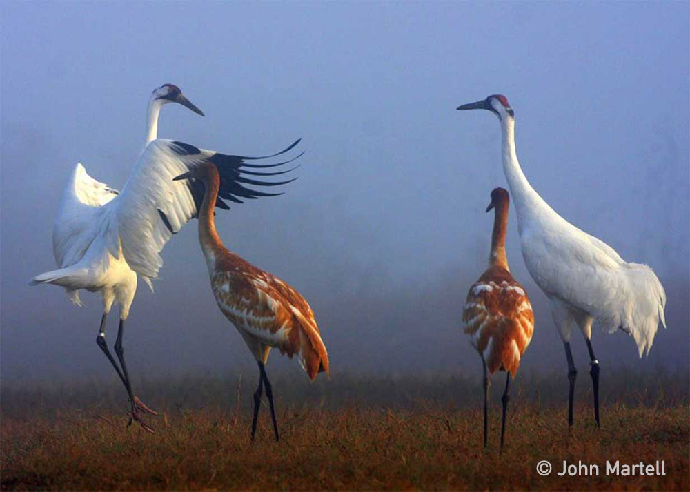
Figure 8. Whooping Cranes such as these are visitors to the lake. The white birds are adult Whooping Cranes and the smaller birds are immature Whoopers. ( Photo by John Martell ) Figure 9. This beautiful landscape looks like it was made for a “stopover area” for Whooping Cranes. But in addition to its beauty, the area provides necessary features to help the Whoopers rest and forage in a peaceful location. Flight glide path clear of obstructions are good for Whooping Cranes to fly in and land near roosting sites. There are few minor thick bushes and trees in or near landing site which helps to make for safe landings and departures. Once the Whoopers have landed they can forage for local foods, (insects, seeds, frogs and other small animals). Then when they are ready, the Whoopers can follow the gradual or gentle slopes into the lake where water is shallow - 2 to 10 inches deep for roosting sites. In addition, there is extensive horizontal visibility from roost site so predators can be detected. Farm grain fields or pastures land is within one mile of stopover site for foraging.
The largest COE reservoir in the U.S.
Lake Sakakawea, the largest COE reservoir in the U.S. was the 5th stop for the FOTWW-COE “stopover habitat” team. They met with Lake Manager Aaron Gregor to learn about the lake and discuss any “stopover habitat” opportunities for Whooping Cranes. Later the team and Lake Manager Aaron visited a small portion of the lake shore.
Lake Sakakawea is 178 miles long, six miles wide at its widest point. It’s shoreline is 1,884 miles. The lake contains a third of the total water stored by the Missouri River mainstem reservoir system.
Wildlife is abundant on project habitats. Endangered species including the least tern and piping plover nest on the lake sandbars. Whoopers and peregrine falcons visit the lake occasionally. Bird watchers, hunters and fishermen use the project wildlife resources in large numbers.
The FOTWW-COE team and Lake Manager Gregor visited several sites on the lake to discuss Whooping Crane “stopover habitat” features. The sites visited were all quality habitats. Mr. Gregor estimated that there were 200 more areas around the lake shore similar to the ones we visited. FOTWW’s Wildlife Biologist McConnell, after visiting many more habitat sites and studying satellite photos believes that the Lake Manager’s estimate is conservative. In any case, McConnell declares “there are an abundance of excellent stopover habitats on Lake Sakakawea”(See fig 9).
Figure 10. This Lake Sakakawea site has a wide shore for Whooping Cranes to land. And there is a small water pool inward that can provide additional roosting area in shallow water. There are no bushes/tall grass that would hide predators. Importantly, numerous grain fields are nearby where the Whoopers can forage.Figure 11. Some shallow water areas like this one on Lake Sakakawea are located on shores of most lakes. Such areas provide excellent stopover sites for Whooping Cranes. Extensive horizontal visibility allows predators to be readily observed. Occasionally, as the grass and bushes grow taller, prescribed fire may be needed to set back the growth.
The FOTWW-COE “stopover habitat” team made its sixth visit at Fort Peck Lake and Dam in Montana. With a volume of 18,700,000 acre feet when full, Fort Peck is the fifth largest artificial lake in the United States. It extends 134 miles through central Montana, and its twisting, inlet-studded shoreline has a total length of some 1,520 miles. The lake covers an area of 245,000 acres, making it the largest in Montana by surface area,
The reservoir is also a tourist attraction, with 27 designated recreational sites bordering its shores. Bordering nearly the entire reservoir is the 1,719-square-mile Charles M. Russell National Wildlife Refuge, which has preserved much of the high prairie and hill country around the lake in a more or less natural state.
Together, Charles M. Russell National Wildlife Refuge and UL Bend National Wildlife Refuge encompass an area of 1.1 million acres including the 245,000 acres Fort Peck reservoir that span about 125 air miles along the Missouri River, from the Fort Peck Dam west to the boundary with the Upper Missouri River Breaks National Monument. Given the size and remoteness of Charles M. Russell, the area has changed very little from the historic voyage of the Lewis and Clark expedition, through the era of outlaws and homesteaders, to the present time. Elk, mule deer, pronghorn, bighorn sheep, sage and sharp-tailed grouse, and bald eagles make the Refuge home.
After discussing the natural resource objectives for Fort Peck Lake with staff members the FOTWW-COE team and staff members made a tour of the lake property by boat to examine the most likely places that would provide Whooping Crane “stopover habitats”. We traveled 64 miles on the lake that has a total length of some 1,520 miles to observe some of the shore area that would be suitable as “stopover habitats”. In some areas westward of Fort Peck the banks are steep and shorelines are small and not suitable for Whoopers. Importantly, the number and high quality “stopover habitats” that we observed was overwhelming. Due to time constraints we could make a reconnaissance of only part of the lake.
FOTWW’s McConnell explained that: “Based on observations by FOTWW and Fort Peck staff, we conservatively estimated that a minimum of one good “stopover habitat” per every two miles would be reasonable. That computes to 750 “stopover habitats” on Fort Peck Lake. The day we visited the lake was 6 feet above normal but numerous shorelines were good “stopover habitats”. During normal (lower) water level, more shore area is exposed and stopover habitats are much larger.
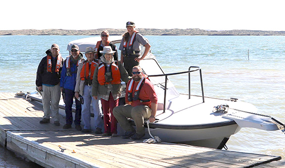
Figure 12. Fort Peck Lake. This is the crew that made the 65 miles boat trip on Fort Peck Lake to evaluate Whooping Crane “stopover habitats”. The crew includes two Friends of the Wild Whoopers officials and five U.S. Army Corps of Engineers natural resource personnel. Names from left to right- Top row: Cindy Lott, Resource Specialist-; Patricia Gilbert, Natural Resource Specialist, Ft. Peck; Bottom row: Zachary Montreui, Omaha office; David Hoover, Conservation Biologist, Kansas City; Chester McConnell, FOTWW Wildlife Biologist; Dorothy McConnell, FOTWW Field Assistant; Reece Nelson, Natural Resource Specialist, Omaha office.
One more stop before heading home
As the FOTWW-COE team headed back to their home offices, they made one more stop at Pipestem Lake in North Dakota. They met with Lake Manager James Dixon who is the only staff person. The team discussed the need for Whooping Crane “stopover habitat” and what could be done on Pipestem Lake to protect, maintain and develop stopover habitat.
Pipestem Lake is small with an 840 acres conservation pool. The length of the conservation pool is 5.5 miles and the shoreline is 14.5 miles. The FOTWW-COE team drove around the lake and observed many White Pelicans, egrets, killdeers and other birds. birds along the shore. The team estimated that 35% of the shore area is good Whooping Crane stopover habitat (Figure 13)..
The team recommended development of a policy on Off-Road-Vehicles; ATV use; invasive plants and an agricultural program.
Figure 13. This peninsular near the dam is an excellent “stopover habitat” for migrating Whooping Cranes. Water along the shore is shallow (2” to 11” depth) and suitable for the cranes. Likewise the low growing green vegetation is a good foraging area for Whooping Cranes. Note the White Pelicans along the shore.
***** FOTWW’s mission is to help preserve and protect the Aransas/Wood Buffalo
population of wild whooping cranes and their habitat. *****
Friends of the Wild Whoopers is a nonprofit 501(c)3 organization.